


Covering 2.83 sq. km., Hadar constitutes 4.4% of Haifa’s area. Its 40,120 residents make up 14.4% of the city’s population. Hadar lies on Mount Carmel’s northern slope between the Carmel area and the lower town area. It is now a neighborhood in flux with numerous new immigrants, mainly from the former Soviet Union, living there.
The main street, Herzl Street, is a busy bargain shopping street with many shops, bazaars and discount houses. Some of the educational institutions like the Technion- Israel Institute of Technology and Kiach High School have moved away; some like Chadash, Bialik, Bosmat and Even-Pina High Schools have closed down and some like the Re’ali school still exist. In 2007, the “Student Village” was created as a collaboration between the Haifa Municipality, the University of Haifa, and the community project Perach. As part of the project, members of the student village, who come from a variety of academic institutions in the city, move to Hadar, where they work in a variety of programs and courses. Each student receives a large scholarship for participating in the program.
Hadar is divided into four areas:
Hadar West has a population of 8,100, 67% of which are Arab. This area is home to the Ba’hai Shrine and the Universal House of Justice which are located in the Ba’hai Gardens sloping from the Carmel ridge down to the German Colony. The magnificent Ba’hai Gardens, which descend down the Camel slope to the German Colony area, are one of Haifa’s main tourist attractions and they have recently been granted the status of a UNESCO World Heritage site. Adjacent to the site a wave of renewal has led to the opening of art galleries, antique shops and small coffee shops.
The following facilities and institutions can be found in this neighborhood:
- El Kharame Elementary School and High School (Map)
- Nazarene Nuns elementary through high school (Map)
- Sheizaf Municipal High School
- El-Mutanabi High School (Map)
- Learning Enhancement Center
- Shema – center for children and youths with hearing disabilities (Map)
- Abas Community Center (Map)
- Senior citizens clubs
- SHIL – Citizens’ Advice Bureau (Map)
- Beit Chagall – center for painters and sculptors (Map)
- Family Health Clinics (Tipat Halav) (Map)
- The Ba’hai gardens and shrine (Map)
- Massada station of the Carmelit (Haifa’s underground funicular railway) (Map) CURRENTLY UNDER RENOVATION UNTIL FURTHER NOTICE
Hadar Eliyon (Upper Hadar) has 10,700 people residing within it, 36% of which are new immigrants. The district contains many Charedi (ultra-orthodox) enclaves and the relevant institutions.
The following facilities and institutions can be found in this neighborhood:
- Leo Baeck Elementary School (Map)
- Yavne Religious Elementary School (Map)
- Atid Ironi Dalet (Map)
- Beit Ya’akov – Charedi Elementary School (Map)
- Beit Yosef – Charedi Elementary School
- Moreshet Torah – Charedi Elementary School (Map)
- Masoret Yisrael Charedi Elementary School (Map)
- Urim Elementary School (special education) (Map)
- ORT Chana Senesh Technological School (Map)
- ORT Chana Senesh Community Center (Map)
- Rotshchild Nursing School (Map)
- Bnai Zion Medical Center and Outpatient Clinics (Map)
- Family Health Clinics (Tipat Halav)
- Senior citizens club (Milab)
- Golomb station of the Carmelit (Haifa’s underground funicular railway) (Map) UNDER RENOVATIONS UNTIL FURTHER NOTICE
Hadar Merkaz (Central Hadar) is considered the heart of Hadar, and it has 10,100 people living in it. The Central Hadar area contains many of Haifa’s architectural, cultural and historical landmarks. Central Hadar is the largest area of Olim in the Haifa area, with 43% of the residents being Olim.
The following facilities and institutions can be found in this neighborhood:
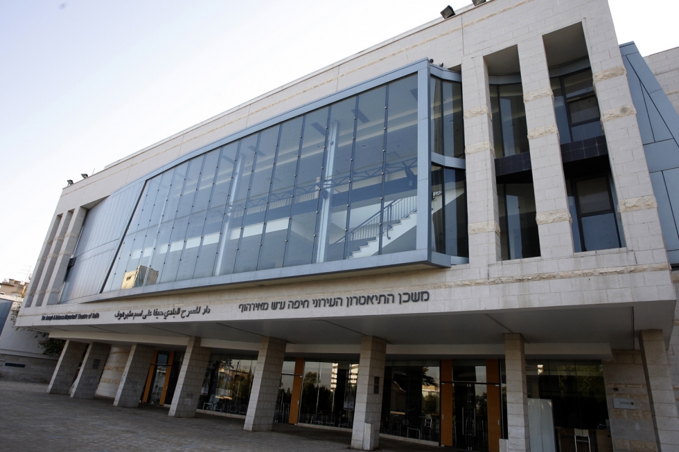
- The Haifa Municipal Theater (Map)
- The National Science, Technology and Space Museum – Madatech (Map)
- Reali Elementary and Junior High private school – Hadar branch (Map)
- The Central Library – Pevzner and the Graphotek picture library (Map)
- Hadar Community Center (Map)
- Binyamin Park (Map)
- Memorial Park (Gan Hazikaron) (Map)
- City Hall and the Municipal Engineering Authority (Map)
- The State Comptroller’s Office (Map)
- Army Recruitment Center (Map)
- Hotels: Art Gallery Hotel, Hotel Theodor, Eden Hotel Haifa, Bay Club Hotel
- Migdal Hanevi’im office and shopping center (Map)
- Supermarkets – My Market (Map), Keshet Ta’amim (Map)
- Al-Meidan Theater (Map)
- Senior citizens homes: Beit Margash (Map), Beit Ya’ara (Map), Nof Hadar (Map), Graff (Map), and Hemdat Avot (Map)
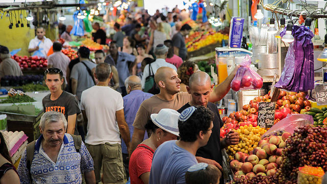
- Talpiot fruit and vegetable market (Map)
- Leumit Health Fund central office (Map)
- Me’uhedet Health Fund central office (Map)
- Panamanian (Map) and Norway (Map) Consulates.
Hadar East has a population of 10,400 and it is divided into three neighborhoods; Yalag, Geula and Ramat Viznitz. The first two are among Haifa’s oldest Jewish neighborhoods and are mainly ultra-orthodox and Viznitz is a special neighborhood where most of the inhabitants belong to the Viznitz Hassidic community, headed by their own Haifa Rebbe Eleizer Hager. This area of Haifa has a large proportion of youth, with a third of its residents under the age of 18.
The following facilities and institutions can be found in Hadar East:
- Zichron Meir Elementary School (Map)
- Yahel Yisrael Elementary and High Schools for boys and for girls separately (Map)
- Torat Emet Elementary School (Map)
- Ulpanat Tzvia girls Junior High and High School (Map)
- Beit Ya’akov Charedi girls school (Map)
- Beit Ya’akov Charedi teachers seminary (Map)
- Charedi synagogues, yeshivot and kollels
- Etzion Community Center and senior citizens club
- The Haifa Rabbinical Court (Map)
- The Maccabi Health Fund central office (Map)
- Family Health Clinic (Tipat Halav) (Map)
- Hermann Struck Museum (Map)